Printing Presses
These maps show the location of printing presses in South Asia between 1556 and 1900. Please read below for a description of each map and use the links on the right to navigate to the map that you seek. Click on the location markers to view more details on specific presses and use the (+) and (-) icons to zoom into the desired location.
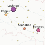 Press Location Map: This map identifies the location of printing presses and allows users to identify the first press(es) established in a particular place. The map will evolve as we add further data.
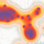 Press Heat Map: This map identifies centers of printing, large and small, and visualizes the intensity of printing activity in particular locations and regions. The map will evolve as we add further data.
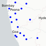 Press Timeline Map: This map gives a historical timeline of the spread of printing across South Asia, indicating the year when print first came to a particular location and when the first printing press was established there.
The Chapakhana website is designed and developed by the Research Computing Center The University of Chicago Copyright © 2018-2019. All Rights Reserved